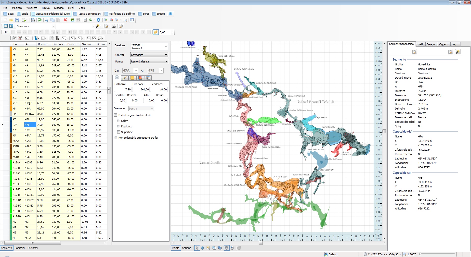
Beim Zeichnen eines Höhlenplan gehört immer ein vollständiger Plankopf dazu. Bei den meisten Programmen muß dieser umständlich erstellt werden. Oft wird eine Vorlage verwendet und die Daten wie Ganglänge etc. müssem manuell ergänzt werden. In cSurvey kann ein Plankopf durch sogenannte Tags – also Variablen – ergänzt werden und die Werte werden dann automatisch eingetragen. Der gestalterische Spielraum für den Plankopf ist natürlich eingeschränkt. Dafür wird das Risiko für Übertragungsfehler verringert und man hat viel weniger Aufwand.
Der Plankopf (VÖH Merkblatt B41a):
- Höhlenname: Jener Name, der im Österreichischen Höhlenverzeichnis ( MB B2) aufscheint. Größte Schrift am Plan!
- Katasternummer: Teilgruppen- und Höhlennummer der Höhle im Österr. Höhlenverzeichnis
- Zweitnamen: Jene Namen, die sonst noch in der Literatur, auf topographischen Karten oder bei der Bevölkerung Verwendung finden
- Lage: Lageangabe unter Verwendung der ÖK 50 (oder ev. Alpenvereinskarten)
- Gemeinde oder Gebiet, Bundesland: Es kann sinnvoll sein, den Gebirgsstock angeben; eventuell die nächstgelegene Ortschaft, wenn die Höhle im entlegenen Randbereich eines anderen Gemeindegebietes liegt
- Basisdaten: Ganglänge, Höhenunterschied, Horizontalerstreckung, Lagekoordinaten (Genauigkeit) und Seehöhe
- Vermessungsdaten: Vermesser (Angabe der Viseure und Entwurfszeichner), Planzeichner, Datumsangaben (Forschungsstand), Vereine
Im Hauptmenü „Print“ klicken und unter „Properties“ den Tab „Information box“ wählen. Dort einen Tag aus der Auswahlbox wählen oder händisch eintippen. Die Position, Schriftart, Größe und Farbe können bei den blau-markierten Optionen geändert werden.
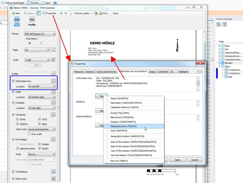
Allerdings sind nicht alle benötigten Tags in der Auswahlbox gelistet. Weitere Tags für die „Information box“ sind:
For stations
NAME station name
NOTE note
FIRSTALIAS first station’s alias
CAVENAME cave name (the one in main properties)
CAVEID cave cadaster id (the one in main properties)
GEOPOS coordinate (lat long)
GEOPOSLAT coordinate (lat)
GEOPOSLONG coordinate (long)
GEOPOSALT coordinate (alt)
GEOPOSCALC calculated coordinate (lat long)
GEOPOSLATCALC calculated coordinate (lat)
GEOPOSLONGCALC calculated coordinate (long)
GEOPOSALTCALC calculated coordinate (alt)
SURFACEV surface altitute
TOSURFACEV vertical distance to surface
Global tags
Tags usable in information box or in graphics object with „text“ property.
ID
NAME
DESCRIPTION
AUTHOR
CLUB
TEAM
DESIGNER
NOTE
GA
SESSIONDATE(n)
SESSIONYEAR(n)
SESSIONCLUB(n)
SESSIONDESIGNER(n)
SESSIONNOTE(n)
SESSIONCLUB(*)
SESSIONTEAM(*)
SESSIONDESIGNER(*)
YEARRANGE
FIRSTSESSIONDATE
FIRSTSESSIONYEAR
FIRSTSESSIONCLUB
FIRSTSESSIONTEAM
FIRSTSESSIONDESIGNER
FIRSTSESSIONNOTE
LASTSESSIONDATE
LASTSESSIONYEAR
LASTSESSIONCLUB
LASTSESSIONTEAM
LASTSESSIONDESIGNER
LASTSESSIONNOTE
Coordinate of the station referred in geographic settings
GEOPOS coordinate (lat long)
GEOPOSLAT coordinate (lat)
GEOPOSLONG coordinate (long)
GEOPOSALT coordinate (alt)
GEOPOSCALC calculated coordinate (lat long)
GEOPOSLATCALC calculated coordinate (lat)
GEOPOSLONGCALC calculated coordinate (long)
GEOPOSALTCALC calculated coordinate (alt)
For graphics object bindable to cave/branch
Path parameter is the path (cave sensitive) to get data for (for example: cave\branch1\branch2)
NAME(path)
ID(path)
DESCRIPTION(path)
SVILTOT(path) total length
LEN(path) „
SVILPLAN(path) Horizontal length
PLANLEN(path) „
DISPOS(path) Positive drop
PVRNG(path) „
DISNEG(path) Negative drop
NVRNG(path) „
DIS(path) Total drop
DISTOT(path) „
VRNG(path) „
SEGCOUNT(path) Shot’s count
EXSEGCOUNT(path) Excluded shot’s count
GEOPOS(path) coordinate (lat long)
GEOPOSLAT(path) coordinate (lat)
GEOPOSLONG(path) coordinate (long)
GEOPOSALT(path) coordinate (alt)